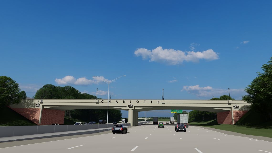
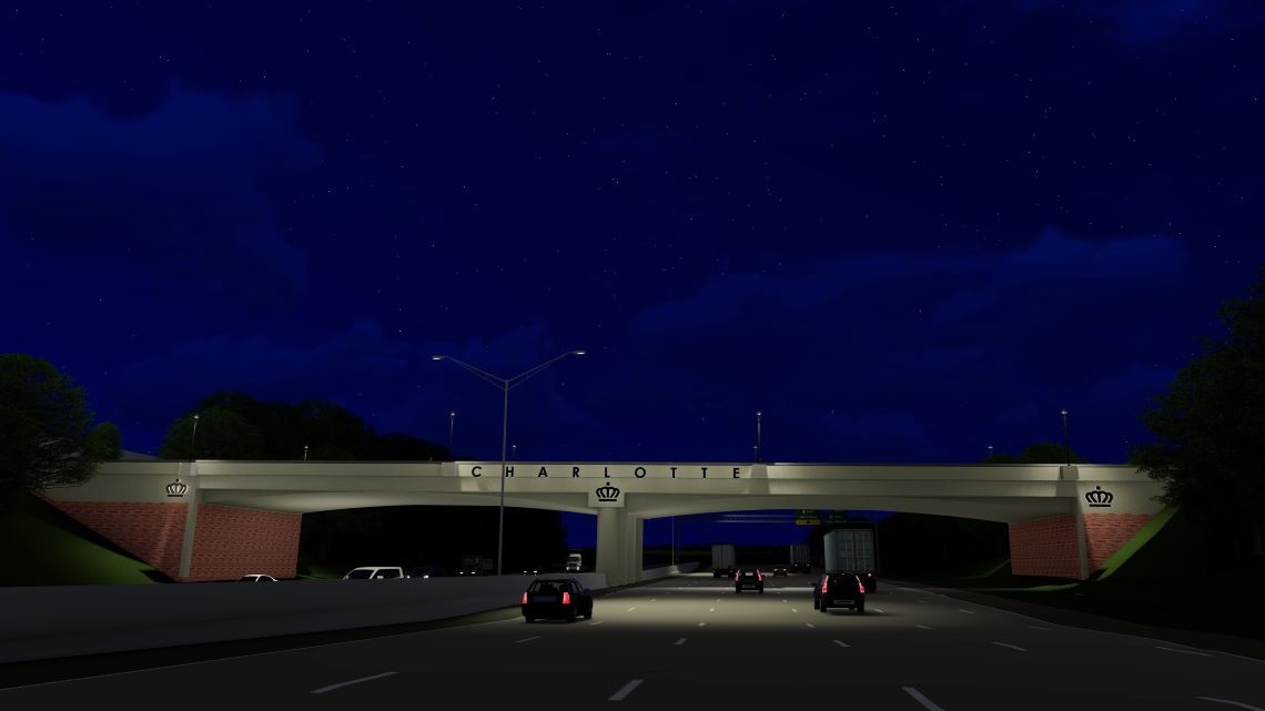
North Bridge Over Interstate 85
Announcement
May 4, 2026 - Work at Doug Mayes Place continues, with the current phase expected to finish in late 2026 and -open to traffic. The full project, including new bridges over I-85 and Doby Creek and roadway improvements along Louise Rose Place, Research Drive and David Taylor Drive, remains on track for completion in 2028. Additional traffic shifts are planned. See full update below.
- Project typeBridge, Transportation
- Project budget$50.7 million (includes all costs associated with the project such as planning and design, acquiring the right-of-way, utility relocation, consultant fees, construction, signalization, permits and landscaping)
- Project phaseConstruction
- Construction contractorDane Construction
Detailed map of the final design in context of the University City area and the J.W. Clay Streetscape Project. View a larger version(PNG, 22MB) of this image.
Project Update for May 2026: Work within the current phase at Doug Mayes Place continues and is expected to be completed in the third quarter of 2026, at which time the area will re-open to traffic. The overall project -- including construction of new bridges over I-85 and Doby Creek, as well as roadway improvements along Louise Rose Place, Research Drive, and David Taylor Drive -- remains on track for completion in late 2028. Temporary traffic control measures that are necessary for public and worker safety have contributed to congestion and access impacts for nearby businesses and residents. Additional traffic control will be implemented soon along Research Drive and David Taylor Drive, including traffic shifts and temporary pavement configurations, which may result in continued short-term travel impacts. We appreciate your patience as construction progresses. These temporary impacts are necessary to safely advance the project and deliver long-term improvements to mobility and connectivity.
Project Overview
The North Bridge over I-85 will be located in Charlotte's northeast corridor and will provide connectivity across I-85, linking residential, retail and educational uses in University City on the east side of the interstate to the employment center of the University Research Park on the west side. The project will provide an alternative route to both the W.T. Harris Boulevard and Mallard Creek Church Road interchanges with I-85. In addition, the bridge will provide a direct connection between all of the following:
-
University Research Park
-
The future Doby Creek and Barton Creek greenways
-
The J.W. Clay station of the LYNX Blue Line
-
University of North Carolina at Charlotte
This bridge will serve as a monument entrance into Charlotte and provide facilities that accommodate all modes of transportation from cars and public transit to bicycles and pedestrians.
As a part of the National Environment Policy Act process, the City of Charlotte, in cooperation with the Federal Highway Administration and the North Carolina Department of Transportation, engaged the community to help complete an environmental analysis and preliminary design that reflects the region's vision for infrastructure connectivity.
Public participation was important throughout this project to help identify alternatives that meet the city's goals to maintain the growth and vitality of the community and to support a healthy economy for Charlotte.
Project Goals
-
To provide connectivity across I-85, linking residential, retail, and educational uses in University City to the employment center of the University Research Park
-
To provide an alternative route to both the WT Harris Boulevard and Mallard Creek Church Road interchanges with I-85
-
To provide a direct connection between University Research Park, UNC Charlotte, the future Doby Creek and Barton Creek Greenways and the LYNX Blue Line J.W. Clay Station
- To provide facilities that accommodate all modes of transportation: motorists, bicyclists, pedestrians and transit.
Public Involvement
The City of Charlotte hosted the first community information meeting on Tuesday, April 12, 2016 at 6 p.m. at the Oasis Shriners. The meeting was an open house format with a brief formal presentation.
On November 3, 2016, the project team held another public meeting at Elevation Church-University City to shared the preferred alignment of the bridge and get feedback. An online meeting was made available for participants who did not attend.
On June 7, 2017, the project team hosted a meeting at Oasis Shriners to present preliminary design concepts and enhanced aesthetic options for the bridge. A virtual meeting was provided to those who could not attend to select the concept they preferred.
On December 13, 2018, participants reviewed the project’s final roadway layout, learned about the right-of way acquisition process and viewed the aesthetics for the bridge.
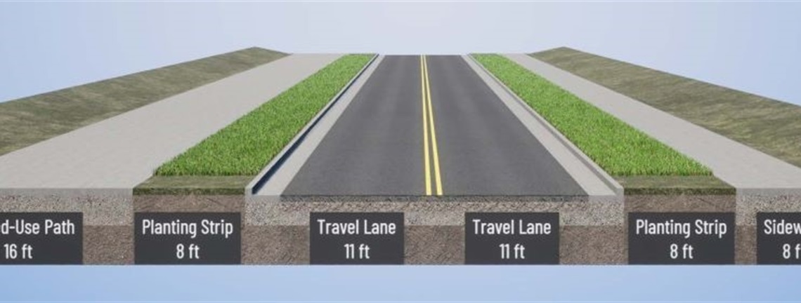
Project Renderings
For illustrative purposes only; specific features could change.
Vicinity Map
