Uptown CycleLink
Program Overview
The Uptown CycleLink is an approximately 7-mile-long network of separated bike lanes that, once complete, will connect more than 40 miles of bikeways into and across center city Charlotte. One segment of the Uptown CycleLink, the 5th Street/6th Street Protected Bicycle Lane, was completed in December 2021 and connects Irwin Creek Greenway to the Little Sugar Creek Greenway and to multiple destinations within Uptown and beyond.
The remaining road segments of the Uptown CycleLink have completed the Advanced Planning & Design phase. City staff and consultants refined the concepts from the 2021 Uptown CycleLink Feasibility Report through public outreach, stakeholder coordination, alternatives and traffic analysis.
Before and After Improvements

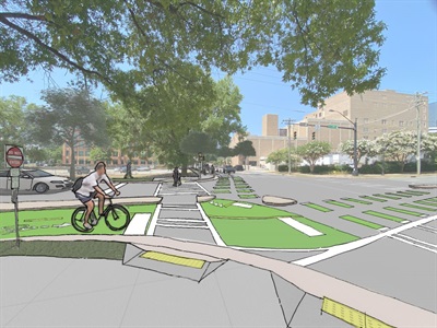
Davidson Street at 6th Street - Current conditions and illustration of improvements after project completion


College Street in front of the Charlotte Convention Center - Current conditions and illustration of improvements after project completion


MLK Boulevard in front of the NASCAR Hall of Fame - Current conditions and illustration of improvements after project completion
Road Segments
Segments with web pages are hyperlinked below
 Belk Greenway Connector: 2.3 miles long; Martin Luther King Jr. Boulevard, College Street & Hill Street (in progress)
College Street & Martin Luther King Jr. Boulevard: 0.6 miles long, College Street from Morehead Street to MLK Boulevard, and MLK Boulevard from College Street to Davidson Street; concept plan(PDF, 3MB) (in progress)
Graham Street & Cedar Yards: from Mint Street to Cedar Street (not yet funded)
Davidson Street: 0.25 miles long; Davidson Street from 4th Street to 6th Street; concept plan(PDF, 3MB) (not yet funded)
Mint Street & Pine Street: 1 mile long; from Mint Street at Palmer Street to Pine Street at 6th Street; concept plan(PDF, 12MB) (not yet funded)
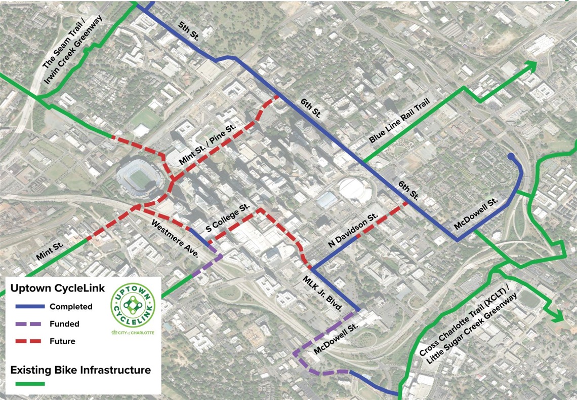
Map of Completed and Planned Road Segments
The city is studying the best ways to modify earmarked streets for the Uptown CycleLink. This is a thoughtful task that requires block-by-block evaluation, design and coordination with adjacent properties, private development and city service providers. The plan is to pursue the implementation of various segments as conditions and funding allow.
Commonly Asked Questions
What is the Uptown CycleLink?
The Uptown CycleLink is a ~7-mile network of separated bike lanes that will connect over 40 miles of bikeways into and across center city Charlotte, enabling safe and comfortable bicycle commuting in a transformative new way. It is a critical focus of Charlotte’s effort to create a “AAA” (All Ages and Abilities) bike network and transform Charlotte into a world-class bicycle city.
Why is it planned where it is?
The Uptown CycleLink alignment is the result of 4 years of planning, public engagement, and an evaluation of every block and corridor in Uptown Charlotte. The initial result of that evaluation was the Uptown Connects study, which was published and presented to City Council in the summer of 2017.
The Uptown CycleLink alignment was chosen in part because it has the least anticipated impact on vehicular traffic. Other key factors include connections to existing bikeways, access to major Uptown destinations, coordination with adjacent land uses, and input from the cycling community and other stakeholders.
When can I go ride it?
You can ride a portion of it today! The CycleLink along 5th Street and 6th Street is open and available for public use, as well as Davidson Street from 4th Street to Martin Luther King Jr. Boulevard, and Martin Luther King Jr. Boulevard from Davidson Street to McDowell Street. Other segments are moving along on separate timelines as funding and resources allow.
Will this reallocate some space that is currently used to move and park cars?
In a word, yes. The primary goal of this project is to create safe and comfortable bike commuting options for cyclists of all ages and abilities. There is no space available in Uptown to create a “AAA” bike network without some impacts on vehicle traffic and parking. The Uptown Connects Study revealed that there are currently 34 continuous lanes for vehicles running east-west through the Uptown and zero for cyclists. This project helps to address that imbalance by reallocating some space that is currently used for vehicles.
After evaluating every block and corridor in Uptown Charlotte, the Uptown CycleLink alignment was chosen in part because it has the least impact on traffic. For example, a 2017 pilot project on 6th Street demonstrated that there was only a 5-minute average increase for drivers traversing the length of the Uptown.
Evaluating potential tradeoffs is a part of every city transportation project. In the case of the Uptown CycleLink, the City determined that the significant safety benefits for cyclists and other Uptown travelers, and the opportunity to connect over 40 miles of bikeways into and across Uptown Charlotte, is worth the relatively minor impact to drivers. That tradeoff is consistent with the city’s Vision Zero Action Plan, the Strategic Energy Action Plan, and our commitment to providing safe and comfortable transportation choices for all Charlotteans, no matter how they choose to travel. Also, separated bike facilities have been shown to benefit businesses, promote public health and wellness, reduce emissions, and encourage more people to ride a bicycle.
Photo Gallery