Eastern Circumferential (Back Creek Church Road Realignment)
Announcement
NCDOT is currently advancing the project by finalizing the utility plans. Once all utility review comments have been addressed and incorporated, the team will move forward with developing the right-of-way plans.
At this time, NCDOT anticipates that utility relocation activities will begin in late 2027. Construction is expected to follow, with a projected start in mid-2033
- Project typeTransportation
- Project budget$12.1 million (includes all costs associated with the project such as planning and design, acquiring the right-of-way, utility relocation, consultant fees, construction, signalization, permits and landscaping)
- Project phaseDesign

Project Overview
This project will construct the Eastern Circumferential from NC-49 (University City Boulevard) to existing Back Creek Church Road to urban street standards for improved safety and traffic flow in the northeastern part of the city. The project will include improvements such as bicycle amenities and sidewalks to accommodate pedestrians, cyclists, motorists and transit users. This initial link in the roadway system will be coordinated with the North Carolina Department of Transportation (NCDOT) project P-5208 to build a railroad bridge and NCDOT project U-5768 to build the portion of the Circumferential between NC-49/University City Boulevard and Hanberry Boulevard.
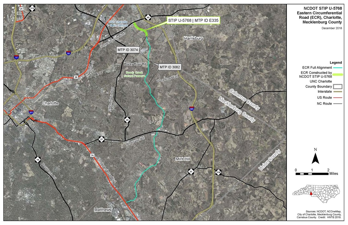
Back Creek Church Road will be re-routed under a new railway bridge, constructed by NCDOT, south of NC-49. This would form the fourth leg of the existing intersection of NC-49 and East Mallard Creek Church Road. The underpass will replace the existing at-grade railroad crossing, which receives a high volume of vehicular traffic. The current railroad crossing on Back Creek Church Road will close permanently and end as a cul-de-sac south of the railroad tracks. This new configuration will maintain street connectivity, increase safety and improve traffic flow across the railroad tracks.
Project Background
Eastern Circumferential Alignment Study (1989) - The City recommended the realignment of Back Creek Church Road in CDOTs Eastern Circumferential Alignment Study. The Eastern Circumferential Road was envisioned as a connection between the UNC-Charlotte/US-29 North area and the US-74 East (Independence Boulevard)/Sardis Road North intersection in Matthews to serve as a circumferential north/south thoroughfare to complement Harris Boulevard and I-485 in eastern Mecklenburg County.
Eastern Circumferential Feasibility Study (2011) - The City of Charlotte conducted a design feasibility study to investigate the construction a new connection between East Mallard Creek Church Road at NC-49 to Back Creek Church Road as part of the planned Eastern Circumferential road. The study evaluated several options for how the road would maintain connection with NC-49 and whether it would travel under or over the railroad tracks. The study looked closely at the impact to homes, business and multifamily developments, potential costs for construction and right-of-way acquisition, street and driveway closures, temporary track for railroad bridge construction, and reconstruction length for the Eastern Circumferential. The study recommended that the road be built under the railroad tracks and that the grade of NC-49 be dropped down in order meet the grade of the realigned Back Creek Church Road.
NCDOT State Transportation Improvement Program Project P-5208 (completed in 2017) - NCDOT proposed constructing 12.2 miles of track adjacent to the railroad mainline between Concord and Charlotte as part of the Southeast High Speed Rail (SEHSR) project. NCDOT recommended closing at-grade crossings along the route to improve safety, including the crossing at Back Creek Church Road, which was identified as particularly dangerous because of its high traffic volume and short distance between the crossing and the NC-49 signal. The project team considered building a bridge over the railroad tracks and NC-49; however, the option was eliminated because the construction area to build the bridge and ramp would affect multiple homes, businesses and a church. Another option was to build a railroad bridge over Back Creek Church Road. This option was also eliminated because it would require the road to be lowered and, most likely, the railroad to be raised in order to achieve the required 25-foot separation. This would have required a huge construction area, extending a half-mile or more and potentially requiring the railroad bridge over I-485 to be rebuilt, thus requiring a temporary detour for trains during construction. Additionally, lowering Back Creek Church Road would also mean that NC-49 would have to be lowered, extending the footprint of the construction area even more.
As a result, the grade separation for a realigned Back Creek Church Road (the future Eastern Circumferential) was pursued and the current railroad bridge south of NC-49 was built. It was completed in 2017.
Project Goals
- To improve safety, connectivity and traffic flow in the northeastern part of the city
- To provide multiple transportation options (walking, cycling, driving, public transit) along the realigned Back Creek Church Road and Eastern Circumferential.
Public Involvement
A public meeting for NCDOT's NC-49 Widening project and the City of Charlotte's Eastern Circumferential project will be held in order to get stakeholder and public input regarding the project's design. A design public hearing will also take place to present the proposed project design and potential impacts. Meeting details will be shared with residents once they are determined. View the "related information" section of this page for links to project presentations and maps.

Rendering of the roadway after project completion. For illustrative purposes only.
Vicinity Map
